Aerial photos and video are great for real estate listings, but did you know YOU and the drone pilot can be fined up to $11,000 by the FAA for each illegal flight?
Now that the FAA rules around aerial photography for commercial purposes (including real estate listings) are fairly clear, it is extremely important to only work with FAA licensed pilots - either a pilot that holds a Section 333 exemption or a person that holds a Part 107 remote pilot certificate.
If you are using someone that does not hold one of these certificates, you could be subject to fines up to $11,000 per occurrence and possible jail time!
However, just having the right credentials does not mean you can fly. There can be local restrictions, either imposed by the FAA airspace classifications, or even the city. Read below for specific detail of the situation in Seattle, currently the fastest growing city in America. The same situation is likely very applicable to your area.
Seattle Airspace Example
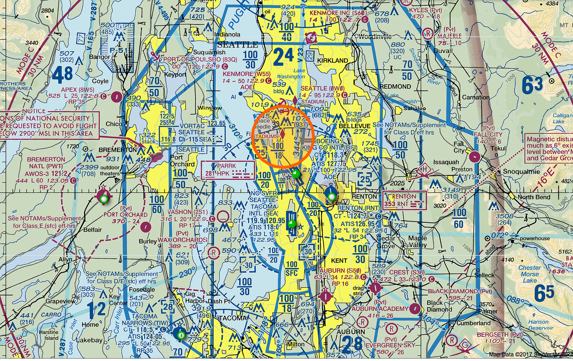
To illustrate the complexity and reason you need someone that knows what they are doing, let's look at Seattle. The Seattle area has many airports that carve up the airspace between class B, C, D and E. Certain high value residential areas, like ALL of Mercer Island and all much of the Seattle-Lake Washington waterfront are actually restricted areas. If you fly here without approval, or meeting the rules, you are flying illegally and subject to fine, or worse...if something goes wrong, you could be looking at potential jail time too!
If you are using someone that has no knowledge of these airspaces, that is your first clue. So do a test and ask them about airspace and see what they say. If they have no idea what the solid blue, dashed blue or other lines means in the picture above, you should not use that person. Or, even what the orange circle means and why it is strictly prohibited to fly there. It is not worth the risk to you and your business. As part of getting a Part 107 certificate, you learn about these airspaces and why it is important to pay attention to them.
So let's look at a couple of specific areas that are prime candidates for aerial imagery.
Mercer Island is a very affluent area where the average home is over $1 million, since it is 10 minutes from downtown Seattle, yet it has it's own village like community. ALL of Mercer Island is in a Class D airspace, because the Renton airport, and a Boeing plant, are just south of the island. The second a drone takes off, you are in Class D airspace. That means you need FAA approval to fly there in the first place - before you fly! To get approval, the remote pilot in command must fill out a form with the FAA and wait for approval. They say it can take up to 90 days! Obviously this does not work well for real estate photography.
To speed the process, we have applied for an exemption from the FAA for the specific purpose of real estate photography on Mercer Island and the Seattle-Lake Washington waterfront, so we are waiting to see if we get approved. If we do, then we should be able to do aerial photography on a much more timely basis and this will be an advantage over other providers as we will be 100% legal!
However...there is more. The City of Seattle has its own rules, of course!
Real estate photography comes under the Film Office jurisdiction. In order to do any kind of photography or video legally in the Seattle city limits for a commercial purpose, you MUST hold a Section 333 exemption, you have to have a permit (3 day period to get that at a minimum and $25 fee) and you need to meet their other rules. A couple of onerous ones being you have to notify all people in the neighborhood 72 hours in advance AND you can't fly within 500 feet of any nonparticipant unless they are under cover of a structure.
How is this practically applied for a real estate shoot? Not very easily...
Per discussions with city employees, they are actively looking at how the Part 107 certificate holders (what FloorPlanOnline people have in most cases) can provide services legally. Let's hope they are smarter about this than other things the city does... Until then we are not flying within the Seattle City limits. If you are using someone that does, and they do not hold a Sec. 333 exemption specific for the purpose of filming (which I highly doubt anyone in Seattle has given it is public info and only 3 people have an exemption in the whole area), then you are doing it illegally. Buyer beware!
So what is the risk of just doing it, either using someone not licensed or without FAA approval? The FAA is now handing out fines, that can reach up to $11,000 for each occurrence. One guy that did not receive monetary compensation, yet the FAA viewed as a commercial purpose, received a $55,000 fine for 5 different events he filmed. If a drone pilot has to land and change batteries, that is 2 occurrences, even if it is the same property. You can see how this could add up.
Plus, the City of Seattle has prosecuted a drone operator that had a drone crash and knock out a lady during a parade. He was sentenced to 30 days in jail. Finally, what if a drone went rogue, hit an airplane or car and caused a catastrophic event. You and others would be sued big time, not to mention you would likely be put out of business.
How would the FAA or City of Seattle find your aerial photos? All they have to do is look on Zillow and view the images. You as the listing agent will be listed. So it would not be difficult for them to pursue this easily just by viewing photos people post online. If they come knocking and you do not have the proof of legally being able to fly, you face fines or more penalties.
The bottom line is not to scare you. But it is to educate you to make the right business decision and hire the right people for the job. It is not worth you saving $50 or $100 to hire a college kid or unlicensed drone operator. We do have licensed pilots in WA, NJ, NY, CT, and TX, and more to come down the road. But as you see, just because you hold a valid license does not mean you can fly in all areas. So be smart and know before you fly and hire the right company for the job!
At this time we have depreciated the Facebook app because of lack of use and required development changes. If you want to post your tour to Facebook, simply copy and past the virtual tour URL to your Facebook business or personal page, add some intro text, and post. Facebook will automatically pull back an image and some marketing text.
If you have a Facebook business page, you can then boost the post - buy a paid ad and push that out to a certain area using Facebook's ad platform. Just know that this would be considered a "Fair Housing" special ad category, and as such, they have removed a lot of targeting capabilities, like target by job title or a specific zip code. You can target by a city, just not a specific zip code.
I am very excited to announce the next step in the evolution of the FloorPlanOnline service offering with our new “go to market” strategy called the FloorPlanOnline Area Manager (“FAM”) program. Photographers, please read more about the program here. http://floorplanonline.com/for-photographers/
In the past, we have contracted with local photographers who would accept jobs and have little engagement or incentive to expand the market beyond them accepting a job. They would leave all the sales and marketing to FloorPlanOnline. The problem is, real estate is a local business, and having local sales people means less money can go to the person doing the actual work and engaging with the customer on a weekly basis. With our new FAM program, we are taking a different approach in how we work with local photographers to help them build their business on top of our platform and our brand. While we continue to do top level marketing such as national tradeshows and vendor programs, the billing and even the centralized technical customer support, we are looking to the local FAM to do the local sales and service work. In exchange, the local FAM has an opportunity to make much more money and build their own business leveraging a national company, but on a local basis. This creates a win-win-win for both FloorPlanOnline, the local provider, and our joint customers because the customer gets a person engaged in, incentivized by and tie to that local business! Churn in the photographer base is greatly reduced and customer satisfaction is greatly increased!
We know many of our competitors churn through various photographers very quickly. This creates service issues, potential distrust and a costly retrain each time. In contrast, we have had people working for us for 12 years! With the FAM program, we are looking to build lifetime relationships with the local provider and our customers.
We need your help. If you know of a photographer, appraiser or other highly motivated person that has a passion for real estate, we would love to talk to them about being a FAM! You can direct them to our Photographer page to get started!
They want to use technology to simplify things, like electronic documents and file sharing.
They want to screen properties BEFORE they ever visit them. This means lots of photos, aerial images, virtual tours and we think floor plans to help people visualize how their family can live in the property, not how the seller currently is living in it. Lots of research out there that says 70% to 90% of buyers want to see floor plans when they search. Leverage this and market it at the listing appointment to get the listing every time!
Be the expert on the process and help people understand it.
Now every buyer can claim their new home right from the FloorPlanOnline virtual tour. With the click of a button, the buyer sends a request to you as the listing agent to approve giving a copy of the photos and floor plans (including the 3D Space planner) to the buyer in their own private HomeDiary account. Now, that great content created on the "For Sale" side of the transaction can live on with the "For Living" side! No other virtual tour platform has this capability because no one else has their own 3D floor plan tool that can do the amazing things the FloorPlanOnline tool can do!
Right now, the Claim Home feature is live on the Full Screen tour. We will be working to add it on other tour versions. If you want it on your tour now, simply go to Edit Details from the Manage Tours page and select the Full Screen tour option, then save at the bottom. The Claim Home button will then show under tools as you see in the above screen shot.
Then just look for the approval request from the buyer. You can also point out this feature to the buy side agent as a courtesy to them and their client.
We are currently working on some market research as part of our participation in the NAR REach program around HomeDiary options and integrations with some of the tools you already use, such as transaction management platforms, CRM systems and even some larger regional brokerages. So stay tuned for some interesting things to come as we approach the National Association of Realtors' annual convention.
This is an update to my original post back in 2017.
Drone photo and video footage can add some cool and interesting views to real estate listings. But to create them for real estate purposes, which is considered a commercial use, the person controlling the drone (the “Pilot in Command”) must be legal, which means they should have an FAA issued Remove Pilot certificate (small UAV license). Failure to do so can mean fines as well as possible jail time. To get a certificate, you must pass the remote pilot knowledge test, which asks questions about airspace, weather, who qualifies, airport operations, emergency procedures and pre-flight/flight procedures, to name a few. just because you do have a license does not mean you can fly everywhere. Many areas around larger cities do have airspace class restrictions and if you do not know what they are or how to get approval, you are putting your client, and yourself at huge risk, by not only fines by the FAA, but possibly personal liability if something bad happened.
I passed my test in 2017, so I am a sUAV pilot! I thought I would pass along my experience if you are interested. I will say, I think it is a good idea that people have to go through this whole process, and in fact, I would almost suggest a hobbyist have to go though it as well, given the consequences of someone doing something stupid with another plane in the sky….but that is for another day. I did learn a lot and have a good appreciation for why there is a need for this process.
Studying. I started to read some different documents (like the Pilots Handbook), but could barely keep myself awake. So I finally broke down and bought access to a video tutorial site. I used these guys. http://remotepilot101.com Jason does a great job going through the material and emphasizing what is important and what is likely to be on the test. It is $149 and well worth it because you will need to retake the test every 2 years and your initial purchase covers you for future years. After each section there are sample questions, that look very similar to the real test questions. There is a final exam at the end as well. Here is my drone tutorial I created. But to get the full effect you need to buy the video course and then you can understand what these are all about.
This is all I did. I would suggest reading at least the summary to the Part 107 rules & regulations. There are a few questions about eligibility. Here are some helpful resources:
Taking the test. You need to go to an official testing station to take the computer test.
Need to schedule the test first. There is a list of testing centers below but I was told you have to call PSI to schedule it. 800-211-2754 – It costs $150. They also said you need to be a member of www.aopa.org and you get $10 off if you are member too. I signed up for the free student membership. see the test centers here
The Test. It was pretty much like the sample questions in the RemotePilot101. They had some images as part of the questions. Note…I was provided a test supplement, but I thought it was really more for a real pilot’s test as the lady also gave me some other measuring tools and she did not mention that the images ARE IN THE BOOK…so I did not even use it…but the images in the test questions ARE in the book, and this makes answering the questions a lot easier, as I could not really read some of the details on the computer. So, while I did pass, I probably would have gotten at least 3 or 4 questions right had I just looked in the book! It took me about 45 minutes. I answered most questions, I flagged a few and then went back through each question using the 1990’s style navigation…so you do have an opportunity to go revisit any question again. When you are done, close out and the testing person gets your results, and then prints your certificate if you pass!
Getting the Remote Pilot License. Register and then go through the process here iacra.faa.gov. Note – you need the Knowledge Test ID and this is not available until 48 hours after your test…I guess someone needs to put in a punch card or something into the old government computers…
I finalized my application at iacra.faa.gov. The process was a little clunky, but it found my test and you digitally sign the documents. So, I believe at this point I am an official Drone Pilot! Not that I will be doing a lot, but given I run the company I thought it would be good to have the knowledge and capability…and hey, I have to admit, it is fun (except when there is a fly away…which I did experience playing around at Weatherby Lake). Remember the return to home button.
After a few days you can log back in and print off your temporary certificate! You do not need to wait to fly to get yours in the mail.
One last thing I thought was funny. One of the test questions involved my home town in Iowa – Onawa. Population 3000. What are the odds of that??? I thought it was destiny that I should become a Drone Pilot, aka DronebyCone.
Getting a Drone. In the Seattle area, we have 4 different drones. Two DJI Phantom 3 Advanced and two DJI Mavic Pros. Based on my experience, the Mavic is easier to use and there is less risk of it losing connection and having the drone go crazy. DJI is to come out with an update to the Mavic soon (as of April 2018), so I may get one of those. DJI, Amazon or eBay are good sources to buy. If you buy the drone other than from the DJI website, you can still buy the DJI Care, which is crash protection but you need to activate it BEFORE you ever fly. Check our their service options here. I am not sure you really need 4K video since most computers are NOT 4K and 60% of users are on mobile anyway. But the Mavic does shoot in 4K video and good photo size.
Insurance. To work with FloorPlanOnline, you need insurance. I would imagine the larger brokerages will require some kind of coverage as well. I am investigating options, including a possibility to have an overall umbrella policy to cover all activities within our network. I was told this group www.modelaircraft.org comes with $2.5 million of liability insurance, but when you look at the details, it DOES NOT cover business pursuits. So investigating other options. I found an app called Verifly where you can buy insurance on demand for $10-$25 for 1 hour within 1/2 mile radius of your flight (price varies based on where you are and the risk to them). So this might be a good option starting out. I have read some other posts that insurance can run $800 to $1000 per year and one of our providers mentioned a renewal bill for $1500! So, price accordingly! Your break even on number of jobs at $10 each for insurance is 120 or so…
Preflight Checklist. As I am helping out as the PIC before our Seattle provider Christine gets certified, my first job was to be today. Well, like a good certified PIC, I first checked the airspace, and low and behold, the area I was going to shoot in is a class D space that is controlled from the ground to 2500 feet! So, I had to refresh myself on the process AND get approval from the Renton ATC. Note…the new process is you have to submit an airspace authorization through the FAA’s website. There is a small UAV button on the main page that takes you to this form https://www.faa.gov/uas/request_waiver/ you have to fill out IF you need airspace authorization. So I thought I would just include this in a checklist that could be used every time. See my Checklist. Feel free to print it out or request a copy.
If the first item comes back you will be in a class G, then you can stop and go shoot after checking the Notams/weather, but otherwise, you need to get clearance. It turns out a lot of high priced property (like all of Mercer Island, WA) is included in Class D airspace in the Seattle area as you can see. The dashed blue line means Class D airspace and the [25] means it is from the surface to 2500 feet. So to fly in these areas you must get clearance to be legal. It is a good idea to go to Skyvector and just look around the areas you normally will serve to get a feel for what kind of airspace you will be dealing with. If we do a lot of Mercer Island stuff, it will become a pain in the butt fast having to call every time…and the 90 days in advance thing does not fly with real estate, so warn your clients of the possibility of reshoots! But hey…we are being legal and I know I do not look good in an orange jump suit.
That is about it. I think there is lots of opportunity to provide some cool aerial images, videos and even expand the services of what we do and who we work with. So get going, start studying and get your remote pilot license!
How to sell it. We are rolling out a new order from that can merchandise anything you might want to sell. We are experimenting in Seattle with some custom videos. You can see some examples of the videos on our Vimeo channel: https://vimeo.com/floorplanonline If you want to provide this kind of content we can leverage our production group, and when the new order from comes to your market, it will be part of the order flow. Contact us for questions there.
Privacy & Cookies: This site uses cookies. By continuing to use this website, you agree to their use.
To find out more, including how to control cookies, see here:
Cookie Policy


 own 3D floor plan tool that can do the amazing things the FloorPlanOnline tool can do!


You must be logged in to post a comment.